Day 12 Lares Trek Day 6- Ollantaytambo to Machu Picchu
This morning we had the option of sleeping in, or getting up early to hike up to the Pinkuylluna Archeological site high above the town of Ollantaytambo. The Dave’s Rich, and I decided that we had plenty of time to sleep when we were dead (besides which, none of us can sleep past 5 ).
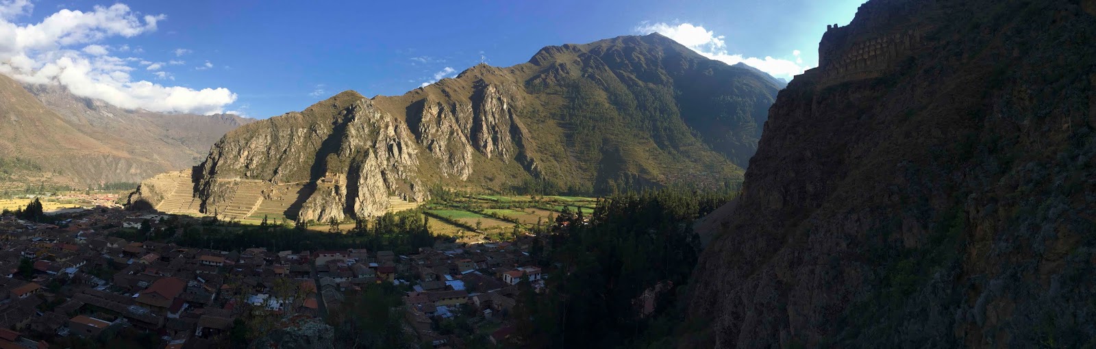
Ollantaytambo is the jumping off town for Machu Picchu which means it is generally very busy, but at 6:30, things are pretty quiet.
 |
| Early morning in Ollantaytambo |
 |
| Stop to smell the roses |
 |
Hike to grain storage facilities high above Ollantaytambo
|
The town was built in the middle of the 15
thcentury by Pachacutec at the confluence of 2 valleys, the Urabamba Valley and the Patakancha Valley, together forming the Sacred Valley into Machu Picchu.
During the Spanish conquest of Peru, Ollantaytambo served as a temporary capital for Manco Inca, leader of the resistance against the conquistadors. He fortified the town and its approaches in the direction of the former Inca capital of Cusco, which had fallen under Spanish domination.In 1536, on the plain of Mascabamba, near Ollantaytambo, Manco Inca defeated a Spanish expedition, the only defeat the Spanish suffered at the hands of the Incas.
Many of the old 15
thcentury buildings are still in use, and some say this is the oldest continuously inhabited city in South America. The town is shadowed by the Fortress on the northern hill and the granaries built high on the southeastern hill.
 |
| Hike to grain storage facilities high above Ollantaytambo |
 |
| Everyone slept in but the 5 of us (I'm taking the photo) |
 |
| Grain storage facility |
Beto explained, in great detail, the construction of the granaries. The granaries were situated in this location for several reasons (1stand foremost is that I think that the Inca’s tried to find the most difficult site possible in which to build); it was 1. Easy to defend against enemies, 2. in a location that remained cool, shaded from the sun most of the day, 3. In a position such that updrafts from the valley floor provided great circulation to keep the grain dry. The hike was challenging this early in the morning, but well worth it. The Inca’s certainly belong on the TV program “Engineering Marvels”. The storehouses were staggered vertically and the windows allowing circulation also were staggered in the same way. This forced the air to circulate throughout drying the grain. There were also channels within the walls for additional circulation, reducing both temperature and humidity.
We descended (slowly) and walked through the town to the Temple Hill and Fortress archeological site (Raul did not like us to call these ruins). By now, the town was awake and bustling. We stopped in the main square to take some photos (and use a bathroom), and met up with the rest of the group (most importantly our wives).at Temple Hill.
 |
| Ollantaytambo |
 |
| Jaguar garbage cans |
 |
| Ollantaytambo |
 |
| Ollantaytambo |
Ollantaytambo was the Gateway city to the Amazon region in Incan times. When the Spanish invaded, it served as the last stronghold for Inca Manco Yupanqi, chief of the resistance to Spanish takeover.
The archeological site is thought to have been reconstructed in the 15th century by Pachacutec with large terraces for farming along with a complex irrigation system. After Pachacutec's death, Inca Manco used Ollantaytambo as a retreat from the Spanish , and it became the site of the only battle ever won by the Incas over the Spanish.
Ollantaytambo is bordered to the west by Cerro Bandolista, a steep hill on which the Incas built a ceremonial center. The part of the hill facing the town is occupied by terraces. Due to the impressive character of these terraces, the Temple Hill is commonly known as the Fortress, but this is a misnomer, as the main functions of this site were religious. The main access to the ceremonial center is a series of stairways that climb to the top of the terrace complex.
The stairways, a bit intimidating for the acrophobics in our group, were, according to Raul, a warm-up for Machu Picchu. The stones for the temple structures were brought to the hill from a granite quarry across the Urabamba River. Transporting the huge stones was quite an engineering feat. To cross the river, they built an island in the center of the river, then dammed the near side of the island. The blocks of granite were then pulled across the man-made land bridge to the island. Next, the land bridge was removed, allowing the river to flow around the island. Finally, a second land bridge was fabricated to the far shore, allowing movement of the stones to the opposite shore. These people must have had the patience of Job! The enormous blocks of granite were then dragged by large numbers of workers, possibly using rollers, up a long, inclined plane to the construction site. You have to wonder how many workers were lost during these construction projects.
 |
| Ollantaytambo Archeological site |
 |
| Ollantaytambo Archeological site |
 |
| Ollantaytambo Archeological site |
 |
| Confluence of the lower Sacred Valley and the Patacancha Valley |
 |
| Temple of the Sun |
 |
Astronomical observatory
|
 |
| Granaries from Ollantaytambo Archeological site |
 |
| Molly made it!!! |
After our tour of the site, we needed to hightail it to the train station for our next leg of our journey to Aguas Calientes (AKA Machu Picchu town). We had the option of walking a kilometer (0.6 mi), or taking one of the many 3-wheeled cabs (like Thai tuk-tuks). We decided, for the experience, to try the “Batmoblie”. They could take 3, so Dave S. joined Jeri and me in a very tight and bumpy ride. Thank God it was only 1K! The price was right, though, 1 Soles per person (30 cents).
 |
| Riding in the Batmobile |
The train station was a real zoo. Other than on foot, the only way to Machu Picchu is by this train, and it gets about 5,000 passengers per day! Trains run from 5:30 am to almost 11 pm every 20 minutes.
 |
| Waiting for the train to Machu Picchu |
Once on the train, the trip was great. The views of the Urabamba River , glaciers and mountains were stunning. There was even complimentary snack and beverage service (the airlines could learn something from them). The trip took about 1:40, but the time went by quickly.
Aguas Calientes is the gateway to Machu Picchu, completely full of hikers. The town is a hodgepodge of buildings on steep hills, and warrens of markets.
Though not planned, we had the option of relaxing at our hotel, or going up to Machu Picchu for the afternoon. Raul offered to come with us and give us a tour, so with the weather being beautiful, we decided to take him up on his offer. Suzie and Rich wanted to chill, so they left for the hotel, the Inka Terra Machu Picchu, and we went off with Raul to get tickets for the archeological site and for the bus ride up (about 2,000’) to Machu Picchu.
 |
| Buying bus tickets to Machu Picchu |
The bus trip up the mountain was on a mostly dirt road hugging the side of a near vertical mountain. It was fine until we met a bus head on, given the road is only 1 ½ car lanes wide. We elected not to wear seatbelts since a mishap with or without them would be a wash. Once we decided to put our faith in the Incan gods, we were able to enjoy the ride and the scenery. There are 2000-3000’ vertical peaks surrounding us leading to the river below.
We made one final switchback and Machu Picchu came into view. Seeing it in person is nothing like viewing the photos.
The complex is immense and truly awe-inspiring. It is sandwiched between the 2 sharp peaks, Machu Picchu (“old peak”), and Huayna Picchu (“new peak”) at an elevation of 7,900’. It is important to pronounce Machu Picchu correctly. There is a reason for the 2nd“c” in Picchu. Machu Picchu (pronounced “Pikchu”) means “old mountain” in Quechuan. Machu Pichu, on the other hand (the way we learned it) means “old penis”. I think I will start using the correct pronunciation.
 |
Machu Pich, at last!
|
Fortunately, the complex was never found by the conquistadores, and was completely taken over by jungle shortly after it was abandoned (why, no one knows, but it is speculated that disease, small pox, may have been the cause). The first European to find it was the German,Augusto Berns, in 1867. He claimed to have found gold in the area and sent back much to Germany in the form of ingots. It is believed that he actually found gold artifacts in Machu Picchu and melted them down. The true discovery was by a Yale professor, Hiram Bingham, in 1911. He was searching for the Lost City of the Incas and was directed here by locals.
There are hundreds of theories about the function of Machu Picchu. Originally, Bingham, thought that it was Vilcabamba, the Lost City (from which the last Inca rulers led a rebellion against Spanish rule until 1572). Most archaeologists believe that Machu Picchu was constructed as an estate by Pachacutec Inca (1438–1472). Construction estimates are in the 40-yr. range, short, considering the building site. Having built our house where it is, I can empathize with the Incan workers.
The latest theory is that this may have been a “university” to study methods of architecture, engineering, and farming, to eventually invade the Amazon region to gain its resources. The Spanish invasion and disease ended this dream. It may also have been a mausoleum for Pachacutec.


It was important for the Incans to develop sophisticated engineering and construction techniques because of the mountainous terrain, large amounts of seismic activity, and relatively high volumes of rainfall. They pioneered construction techniques to avoid earthquake damage that are still studied today by engineers. Trapezoidal construction of windows, doorways and walls is an easily identifiable Incan building technique. The high tolerance of the stone to stone contacts is also seen in the construction, especially in the royal and religious sectors. One interesting thing that the Incans did to increase earthquake resistance was to incorporate natural stones(part of the bedrock) into the buildings’ foundations.
 |
| Trapezoidal construction |
 |
| Local rock in shape of the mountains from bedrock |
They also developed complex drainage systems to both prevent erosion, and irrigate crops, as well as provide water to the inhabitants. Raul was great in his explanations of the architecture we found here.


Astronomy was also very important to the Incans. By knowledge of the winter and summer solstices, they could determine the best times to plant and harvest crops. The Sun Gate, which we will hike to tomorrow, lines up with a structure in the temple section precisely on the 21stof December (the winter solstice). Another interesting archeoastronomical factoid is that is some areas, walls incline exactly 13.2°. The latitude of Machu Picchu is 13.16°, coincidence? I think not! Somehow, using celestial navigation techniques, they were able to calculate their position with respect to the sun (and thereby the equator). They also developed methods for indirect observation of the stars, especially the Milky Way. Using pools of water, they could look at the heavens as a reflection, thereby reducing neck pain, the first reflecting telescopes.
We spent nearly 3 hours walking all over the site with Raul giving us information the entire way.
We finally heard the guard whistles as the sun began to set, signifying that the site was closing. Coming in the afternoon had a huge benefit, no crowds. Raul assured us that tomorrow morning the place will be overrun with tourists. I guess we’ll see. In any case, we had a great afternoon.
We finally got to our hotel well after dark. Although the rest of the group had beautiful rooms, we unfortunately got the runt of the litter. The room was terribly musty and the bed only a double bed, which makes for a long night when you are used to a king. The hotel was full, so we were unable to move. I guess we could put up with it for a night. 1stworld problems don’t seem so bad when you see how some people still live in 3rdworld countries.
Tomorrow, we are going back up the mountain on the bus (tempting fate yet again). We will plan to hike to the Sun Gate, then explore the site a bit more.


 Though not planned, we had the option of relaxing at our hotel, or going up to Machu Picchu for the afternoon. Raul offered to come with us and give us a tour, so with the weather being beautiful, we decided to take him up on his offer. Suzie and Rich wanted to chill, so they left for the hotel, the Inka Terra Machu Picchu, and we went off with Raul to get tickets for the archeological site and for the bus ride up (about 2,000’) to Machu Picchu.


No comments:
Post a Comment